History of virar
Arnala is a mostly fishing town, it's port is used by fishing vessels. The Koli folks supply fish to Virar, Agashi, Northern Vasai and to Mumbai. Historically rulers and conquerors who were attracted to Vasai had little or no interest in Arnala. The fort built on an island off of port of Arnala was of more strategic importance to both the Portuguese and Marathas. The most significant landmark in Arnala is St. Peter's Church which can be seen
for some distance from offshore
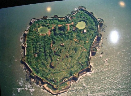
Anara Fort is located at Arnala Islands, which is at a distance of 8 miles north of Vasai in Maharashtra. As it is surrounded on all sides by water, Arnala Fort is also known as 'Jaldurg' or 'Janjire Arnala'. Arnala Fort is mainly on the north side of Arnala Island. The main entrance is on the northern side, while the fort has broad and strong high walls with three gates. Steps are made that lead to ramparts (walls), so one can take a walk around the entire boundary wall. To allow entry in the small rooms and storehouses below, the ramparts have number of small openings in its broad walls. Villagers use some of these storehouses to store their paddy crop. One would come across a canon ball still stuck on the inner side of the west side of the wall near the temple.
In 1516, A local chieftain in Gujarat, Sultan Mahmud Begda originally constructed the fort on the island, strategically located at the mouth of the Vaitarna river. In the 1530s, the Portuguese had established their operations in the coastal area headquartered at Fort Bassein and soon gained control of the island. The Portuguese captain of Bassein donated the island to a Portuguese nobleman who tore down the old fort and began construction of 700x700 foot fort. Though fort was never completed by the nobleman, it remained under Portuguese control for 2 centuries, who used it to control shipping and navigation along the northern Konkan coast.
During the mid 1600s , after a long struggle with the Mughal empire, the Maratha Confederacy came to dominate present day Maharastra. Shivaji Maharaj rebuilt this fort under the leadership of Kanoji Agare, constructing three bastions Bahirav, Bhavani and Bava. In 1737 the then Peshwa Baji Rao I sent his brother, Chimaji Appa, to take the Bassein Fort from the Portuguese. After winning the Battle of Vasai, his general, Shankarji Pant, persuaded Chimaji to launch an assault on Fort Arnala, for its strategic importance to the Maratha navy in assaulting Portuguese interests. Their first assault, coordinated with a Maratha naval force commanded by Manaji Agre, was routed by a superior Portuguese naval force. A second assault on the
fort on March 28, 1737, caught the Portuguese by surprise and forced them to abandon the fort. The victory was commemorated by a plaque installed on the northern wall of the fort and is still visible today.
The Marathas controlled the fort until 1817 when, during the third British-Maratha war, despite successfully defending the fort, they where forced to surrender the fort to the British due to their superior naval power. The Arnala and Bassien forts were returned to the Marathas by the British in the treaty of Salabai, but the forts again changed hands under the treaty of Pune. Today the fort is in a state disrepair.
Reconstruction of the Past Study of NallaSopara
Sopara near Mumbai was a prosperous port of the west coast of India since the beginning of the first millennium B.C. till as late as 15th century A.D. Known under the names of Shutparak, and Suppara and identified with Ophir of Solomon’s times by some scholars, this port center, an outlet to the trade of Deccan, has a rich inscriptional reference. Since 1882 AD, the neighbourhood has been worked by archaeologists to reveal rich findings at least since 3rd century B.C. spread over an area. Yet, the port environment of Sopara has not been firmly established by archaeologists and historians.
The present paper seeks to reconstruct the environment history of the region, and the progressive change in the physical landscape over time and to place the imprints of the cultural, trade history on the evolving landscape. This is done using Spot imageries, both in black and white wave bands and F.C.C. scenes on a scale of 1:50,000 and demonstrates the value in application of imageries in a historical context. Apart from imageries, present day topographical maps, antique maps, archaeological database and field findings have been used in the preparation of the reconstruction maps. The broad extent of the port city and probable site of port landing are also indicated. Incidentally, the paper also throws some light on the later day Portuguese township of Bassein, closeby. The present paper seeks to identify as precisely as possible the port site and situation of an ancient port of North Konkan, namely Sopara by using in combination the imagery visuals, archaeological and historical data, topographical database and field data. The imagery used are Spot imageries on a scale of 1:50,000, both black and white and FCC. They are of dates 1987 and 1991. Later day data have not been used, since the area lying between the Ulhas and Vaitarna rivers along Western Railway have been subject to urban invasion and Vasai-Virar urban development scheme, and urban builtup areas have changed radically the face of the land. Topographical data is drawn from SOI toposheets on a scale of 1:50,000 (47A/16) and on 1:25,000 (47A/16/NW, SW), as well as from antique maps of the 18th century and before, especially for drainage features. Archaeological data used is drawn from Bhagvanlal Indraji excavations of Nirmal and Sopara in 1882, the subsequent ASI excavations in 1939 and 1956, and the more recent one carried out by the South Asian Studies Center, UK in 1993. Historical data is drawn from early Sanskrit and Pali literature and inscriptional records in the area as well as at Nasik, Nanaghat, Karla, Kanheri and Pelhar. More recent historical information on Vasai and neighbourhood is from Portuguese history sources. In addition, sea level fluctuations data during the historic period based upon carbon dating is also used in this study. Mapping is done by integrating the data and plotting inferred information on the spatial frame.
Sopara of the historic past is identified as a site near Nala Sopara railway station between Bassein Road and Virar stations of the Western Railway, on the fringe of Greater Bombay (Brihan Mumbai). It was one of the early ports of North Konkan Coast that finds mention in the Periplus and Ptolemy and was a noted Buddhist and Jain center. Ancient trade roads linked Sopara through Kalyan with Nasik, Paithan and Ter in Deccan. Soparaís continued maritime links are attested by Masudi, Ibn Haukal and Al Beruni between 9th and 11th centuries. The earliest reference occurs in Mahabharata as Shuparak. Suppara Jataka, believed to be of 6th century BC, talks of Sopara as a prosperous port trading with ports of S.W.Asia, Gujarat, Malabar and Srilanka, its experts (navigation pilots- bodhisattvas), and the seas that they voyaged across. From about third or fourth century BC precise historic data can be pieced together. The early archaeological finds in the area center around Nirmal, where in a low mound called the Burud Rajache Kot, a Buddhist stupa was excavated by Bhagwanlal Indraji in April 1882, containing within it a coffer within a brickbuilt chamber, holding images of Maitreyi Buddha set in eight cardinal directions. The stupa itself is dated to the third century BC but the metal images appear to have been placed in it around 9th century AD. A silver coin of Gautamiputra Satakarni of 2nd century BC was also found in the mound. Closeby in the Brahma hill of Vakal, circular burials of unhewn boulders, dating to 2nd century BC have been noted.
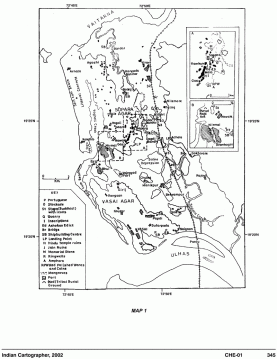
A second area of findings is around Sopara and Gas to its south. In the N.W. of Sopara around the shallow Chakreshwar lake and temple are noted relics of a hindu temple and memorial stones, while south of Sopara, near Ram Kund, and an old muslim grave-yard were found fragments of Asokan edicts VIII and IX. In 1956, fragments of Asokan edict XI were also found in the coastal village, Bhui (Bhuigao). Apart from the above findings, old built up areal and structural lineaments have been noted in the central depression between Nirmal and Sopara - Gas areas, beneath rice fields, and two smaller Buddha stupas south of the Nirmal. In a more recent excavation of 1993, a number of features have been noted - a ring well, fragments of Roman amphorae red polished ware, glass all dating to the beginning of the Christian era, a Portuguese period landing place east of Gas, and a stone paved crossing called Dagdibandh between Gas and Achole. Pali and Prakrit inscriptions in Brahmi have been found in Brahma Hill, Sopara, Gas and Bolinj. Mediaeval hindu and jain temple relics are plenty (Map 1). These archaeological and historical findings fall within two N-S linear belts: Vagholi - Nirrmal-Bhui (Bhuigao) on the weest side and Sopara-Gas on the east. All the findings in Sopara and Gas are to the east of the line of lakes and the settlements, in or near a low terrace sloping east towards a former creek.
The topography of the area can be worked out from the S.O.I. topo sheets on scales of 1:50,000 and 1:25,000, antique maps of the 17th and 18th centuries and satellite imagery. Commencing from the coast, there is a narrow strip of about 1 to 2 km wide sand spit cum beach zone, with present day beaches, about 0.5 km wide along the sea, backed on the land-side by a succession of lines of dead and fossilized dunes stabilized by vegetal cover and linear strips of cultivation in the dune depressions. A number of southward extending spits, developed by southward littoral, long shore drifts of the winter half of the year are split into two zones separated by a deep tidal inlet around Bhui (Bhuigao). Behind this spit cum beach belt lies a wider north to south running low sand ridge, not more than a few meters high mellowed by subaerial denudation into alternating linear mounds and depressions. This is an area of littoral concrete or karal deposits of Holocene period. Carbon dating of about a dozen wood samples taken from depths of 1.5 to 6.0 m at Nirmal and Bhui (Bhuigao) indicate that these deposits were formed between 2500 B.P and 6000 B.P (500 B.C and 4000 B.C.) when sea-level stood higher than at present. Experts also opine that the sea-level may have been almost 0.5 m above the present level two to three centuries before Christ. This belt carries a number of settlements like Vaghola, Nirmal, Vakal, Bhui (Bhuigao), Vajirgad and old Vasai. East of this belt of littoral concrete is a bowl-like depression, about 2 to 3 km wide about 3 to 4 m below the Nirmal ridge which to the south of Nirmal and Gas villages is a saline rice-land. A low tidal depression, about 2 km wide runs west to east carrying at its keel a rocky tidal inlet, that was in existence till a few decades back.
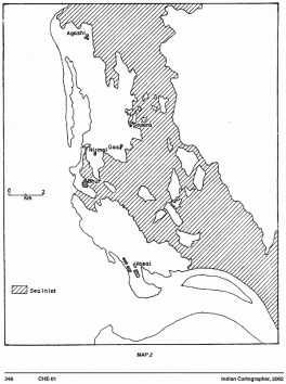
East of this depression is another linear ridge, about a km wide, and few meters high. This again is a belt of sand dunes older than those of Nirmal - Bhui (Bhuigao) belt, with a central linear depression, filled with many fresh water tanks, such as Chakreshwar, Ram Kund and Gas lake. On this low ridge is a second line of settlements Bolinj, Sopara and Gas to the north of the tidal inlet and Girji Chulne and Papdi to the south. To the east of the settlements Sopara and Gas, the land slopes gently to the east, with a terrace about ½ km wide, immediately below the settlements, towards a N-S linear depression, 2 km wide. As noted from the spot heights, the lowest part of the depression lies south of Gas and north of Chulne and Manikpur, at the east end of the tidal inlet. Antique maps of the 18th century show that the keel of the depression was occupied by a water channel, almost 100 m wide, which used to be called the Bolinj creek at the north end, and Sopara creek at the south end. The channel has totally dried up and silted in the central parts south of Bolinj and north of Manikpur. This channel connecting the Ulhas estuary in the south with the Vaitarna estuary in the north appears to have carried tidal waters into it from both sides to make the central depression south of Gas a salt water lake. The construction of the railway track on an embankment 2 to 4 m high seems to have choked the tidal flow, and brought about over time filling up of the depression. Only rudimentary inlets survive as a reminiscence of the past as the Agashi creek in the north and Sopara creek, south of Naigaon. The depression on the east side, almost 0.5 to 1 km east of the rail track rises to higher ground and to the hills of the mainland coast, fringed by a line of settlements like Nilemore, Tulinj, Achole and Gokhivre. It is thus possible to reconstruct the past configuration of the landforms of the area under study through a careful study of the imagery combined with topographical database. Land carrying Agashi, Nirmal, Sopara and Gas appears to have been an island, Sopara Agar, till almost the 17th century with the Vaitarana estuary to its north and the Bhui (Bhuigao) tidal inlet to its south. Another island, Vasai Agar seems to have survived till Portuguese times. This island had Vasai and a number of villages around, and overlooked the Ulhas estuary or Vasai creek. Between the mainland shores and the two islands was a wide-open sea-inlet connecting the Vaitarna and Ulhas estuaries, almost 2 km wide and 15 km long with a central opening to the sea westwards, in the middle. A number of islands appear to have been in the sea lagoon, like Virar, Manikpur, Umele and others. (Map 2)s sea-inlet with tides pouring in and out from three directions would have been deep enough to permit early shipping of sailing vessels carrying on cargo trade. Over the centuries, with a heavy discharge of mud and silt from the Vaitarna and Ulhas as well as from the Tungar and Kamandurg hills to the immediate east would have led to a slow process of siltation of the sea-lagoon and the shrinking of the lagoon to a mere channel of considerable width in the lowest part of the depression. The siltation process hastened during the colonial period due to heavy deforestation in the hinterland, and the construction of the rail track on a high embankment in the second half of the 19th century dismembered the channel, leaving the middle sections dry. In the second half of the twentieth century, the central depression once occupied by the inland sea went through a succession of land cover transformations such as saline lakes, salt pans and saline flats and of late urban builtup areas.
dd In ancient or mediaeval past, especially on the west coast of India no port was a roadstead, because of rough seas, high waves and winds and lack of shelter during the fury of the monsoons. Early landing sites were invariably open sites on protected river banks. In the area under study though the Vagholi-Nirmal-Bhui (Bhuigao) area on the west directly faced the sea, and had small creeks parallel to the sea-face, they do not appear to have attracted a port site. The sheltered inland sea behind the Sopara and Vasi islands approached through either of the estuarine openings was far more ideal for safe sailing and anchoring. The deepest part of the sea-depression lies in the middle, to the north of Manikpur- Chulne and south and east of Gas, where the tidal flows converge from three directions. The most probable port site thus appears to have been to the south and east of Gas, with an adjoining deep water pool for safe anchorage for a few vessels. The largest archaeological findings of the Roman Era lying east of Gas in a low terrace is an indicator in this direction. The findings of the mediaeval stone pavement (Dagdibandh) leading from Gas across the terrace towards Achole, a probable landing site on the mainland face is also suggestive. The sites of ship building and a Bandar of the Portuguese times are also suggestive. A 17th century Kutchi sea manual talks of a regular cargo trade route through the Bolinj-Sopara creek from Gujarat to Mumbai and Thane. As this creek silted up, the cargo vessel traffic slowed down and receded seaward on both ends of the creek. Thus the Sopara Bandar near Nile-more, the Ranpada Bandar and the Agashi Bandar indicate three successive stages of this recession in the 19th and 20th centuries. Agashi was a ship-building center of 17th century where the Marathas as well as Portuguese built vessels upto 500 tonnes size. The loss of port function of Sopara by the 17th century is the outcome of the islands getting fused with the mainland. I
 |
 |
